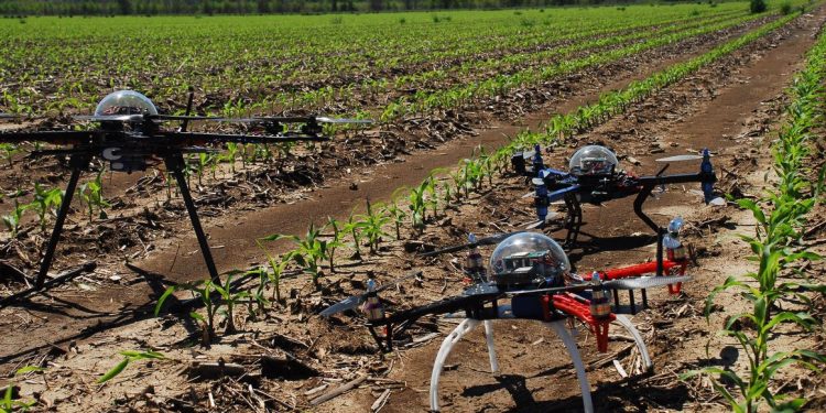
In the spring of 2019, D. Medvedev signed a law on the need to register drones weighing from 250 g to 30 kg, information also appeared (on the official website) on an amendment that allows flying at a height of up to 150 meters and away from people – at a distance of 50 meters.
Laws and regulations on unmanned aerial vehicles (UAVs)
Amendments to the law on UAVs dated February 3, 2020 – Decree of the Government of the Russian Federation dated March 19, 2022 No. 415 “On Amendments to the Decree of the Government of the Russian Federation dated May 25, 2019 No. 658”. The government has amended the bill, now the minimum take-off weight of the drone, which must be registered, should be no more than 0.15 kg, or 150 g. Recall that earlier the weight started from 250 g to 30 kg. Drones weighing between 250g and 30kg must be registered in accordance with the law. Starting March 19, 2022, citizens and owners of drones weighing more than 150g have 60 days to register their device.
Amendments to the law on UAVs dated February 3, 2020 – to the Federal Rules for the Use of the Airspace of the Russian Federation. An amendment that, in fact, allows you to fly quadrocopters and other aircraft models without submitting a flight plan, while at altitudes of no more than 150 meters.
From December 29, 2020, owners of unmanned civil aircraft can receive an electronic registration service for unmanned aircraft using the Unified State Services Portal or the Unmanned Aircraft Registration Portal.
The latest information on the UAV law was updated on March 22, 2021.
Amendments to the law on UAVs dated February 3, 2020 – to the Federal Rules for the Use of the Airspace of the Russian Federation. Obtaining permission for UAV flights through the MFC (update from 04/05/21). Unmanned aerial vehicles will be able to fly at an altitude of up to 150 meters without obtaining permission in the Unified Air Traffic Management System. This is stated in the draft resolution of the Ministry of Transport, posted on the federal portal of draft regulatory legal acts. Responsibility for preventing collisions of drones with manned aircraft and other objects in the air, as well as collisions with obstacles on the ground, rests with the external pilot, the document emphasizes.
To fly an unmanned aerial vehicle, it is necessary to submit a flight plan to the regional center of the Unified Air Traffic Management System of the Russian Federation in order to obtain permission to use the airspace.
For UAV flights over settlements, it is necessary to obtain permission from the local government of such a settlement (with the exception of UAV flights with a maximum take-off weight of less than 0.25 kg).
There is also a simplified procedure for drones with a maximum takeoff weight of up to 30 kg when performing visual flights carried out within line of sight during daylight hours and at altitudes of less than 150 m from the earth or water surface.
But a number of limitations must be taken into account. Flights can only be carried out:
a) outside the control zones of civil aviation aerodromes, areas of aerodromes (heliports) of state and experimental aviation, restricted areas, flight restriction zones, special zones, airspace over places of public events, official sports competitions, as well as security measures carried out in accordance with federal law “On State Protection”;
b) at a distance of at least 5 km from the control points of uncontrolled airfields and landing sites.
Drone vs Quadcopter – What’s the difference?
Drone, quadcopter, unmanned aerial vehicle, UAV – as soon as they do not call unmanned aerial vehicles. This is the most general concept, so let’s start with it. A drone is an unmanned vehicle, but not necessarily a flying one. Instead of screws, it can have wheels, and there are a great many purposes for drones. The word drone itself is translated from English as “drone”. Now it is already difficult to determine who first began to call unmanned vehicles that way, it is only known that the word was actively used already in the middle of the last century.
If we talk about the difference between a drone and a quadrocopter, then it would be more correct to say that one concept can be included in another. That is, the drone is both the “Phantom” familiar to us, and some kind of robot vacuum cleaner.
At the same time, some sources claim that it is correct to call any device without control a drone. Then it turns out that even an ordinary car can be a drone, one has only to put a brick on the gas pedal and send it on a journey without a driver. A dubious statement, so we advise you not to bother with them, because most often they still mean devices that were originally designed to work without a pilot or driver.
Drone is short for “unmanned vehicle”. Unlike the previous word, this abbreviation means precisely aircraft. In fact, it stands for “unmanned aerial vehicle”. This still includes the rotary vehicles familiar to us, but besides them, many other drones that are completely different from each other can also be called this word. Let’s take a brief look at some of them.
– With fixed wing. They don’t have rotors and look like small planes from the outside.
- Rotary UAVs. Drones, which necessarily have rotors, with the help of which the flight is carried out.
- Convertibles. They take off like helicopters, but then they fly like airplanes, relying on wings.
- Gliders. They can be either with or without an engine, they plan by air.
- Tethered drones. Wired, not battery operated.
Given the fact that every day invent more and more new models, this list can be replenished indefinitely. As mentioned above, a quadcopter is a rotary UAV (which, in turn, is a drone). And it is with this concept that most often confusion occurs. The fact is that a quadrocopter is a drone that has exactly 4 rotors, and it would be wrong to call any device that way. Quadcopters are named after the number of propellers:
– tricopter – 3 propellers;
– quadcopter – 4 propellers;
– hexacopter – 6 propellers;
– octocopter – 8 propellers.
Quadcopters are called devices simply because this is the most common model. Hence the error. All rotary-type devices are called multicopters. That is, quadcopters and drones with a different number of propellers belong to this concept. If you want to talk about a rotary UAV without specifying a specific design, it would be more correct to call it just “multicopter” or simply “copter”.
Parameters and characteristics of agricultural drones
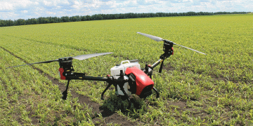
Drone for crop protection AGR A22. 22 l water tank (connectable). Fully built-in magnetic liquid level sensor, real-time feedback on the use of pesticides.
Four piston brushless water pump. Accurately controls spray volume with a maximum flow rate of 8 liters per minute. T-type effective spray width. The pressure relief nozzle can be up to 8 meters and the capacity is 4-14 ha/hour. Accurate obstacle avoidance, better protection for safety. A22 RTK backlight screen remote control. Easy to operate, stable image, highly adaptable user interface, up to 8 hours battery life. Efficient charging, longer battery life. Intelligent fast battery charging, fast charging within 20 minutes.
Drone U16L-4 for agriculture. U16L-4 is designed for aerial spraying, which can greatly increase the uptake of crops and seedlings by pesticides without causing damage to the crops, and greatly increase the vitality of the crops. The U16L-4 is designed to save more than half of pesticide consumption, reduce production costs, and greatly reduce the time workers are exposed to pesticides, thus ensuring the safety of workers’ lives.
Advantages:
– it is convenient to carry (folding conveyor);
– precise control (full or semi-automatic, uncontrolled return);
– reliable (against wind, rain, dust), noise-resistant;
– the use of industrial brushless electric motors, resistance to high temperature, corrosion;
- semi-automatic flight, you only need to change the auxiliary battery;
– The working distance ranges from several hundred meters to several kilometers, the operation mode includes manual control, semi-automatic control and computer program control.
Agras-T30 for agriculture. Agras-T30 is capable of spreading seeds, dry fertilizers and spraying plants. The drone is equipped with a remote control with a built-in 5.5-inch screen and software specially designed for agricultural flights. One controller can control up to three drones.
It has a 30-liter tank and is equipped with 16 nozzles. In addition to the spray tank, the T30 can be equipped with a 40 liter spreader for seeds, dry fertilizers or insects. For automated flight, the T30 uses an RTK GPS system with centimeter-level positioning accuracy, a spherical lidar for avoiding obstacles, FPV cameras in front and behind.
The productivity of the drone when spraying is up to 16.2 hectares per hour. Spray diameter – 9 meters. The performance of the nozzles can reach an intensity of 8 liters per minute. The intensity of the solution supply is regulated by 8 solenoid valves. The drone detects the remaining material in the tank in real time and automatically returns to refuel.
The dry mix and seed spreading system has a feed rate of up to 50 kg per minute, a spreading width of up to 7 meters and a capacity of up to 1 ton per hour. This system also supports real-time weight monitoring and has a rotation sensor to provide more accurate refill alerts.
Two beams with installed nozzles can rise to a certain angle, which makes it possible to capture the lower part of the plants when spraying. This is especially important when flying between orchards and vineyards.
With the help of an omnidirectional lidar and two cameras, the drone tracks the terrain and repeats it at a constant height above the plants. Lidar and LED lighting of the camera allow you to work at night. The spherical radar system recognizes obstacles and the surrounding area in all weather conditions and viewing angles, regardless of the presence of dust and light interference. Automatic collision avoidance and adaptive flight features help keep you safe while you work.
The number of guaranteed battery charge cycles is 1000. The charge time is 10 minutes. The battery is not afraid of overheating, so you can start charging immediately after replacing it. For continuous
two batteries with a capacity of 29,000 mAh are sufficient.
The drone has IP67 protection, is not afraid of dust, moisture and pesticides.
The relevance of the problem of using UAVs
Control over agricultural plantings is currently beyond doubt. But often from a plane it is impossible to assess the full scale of the situation in the fields. Therefore, to accelerate this process, it is necessary to use aerial photography. In agricultural production, small aircraft are traditionally used for this (in Russia – aircraft of the AN-2 type), which is quite expensive and often beyond the reach of small agricultural enterprises. Therefore, in many countries, unmanned aerial vehicles (UAVs) are used to control farmland, the cost of which, from an economic point of view, is many times cheaper than any manned aircraft.
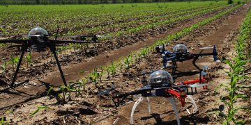
Farmers around the world are actively exploring the possibilities of using unmanned aerial vehicles in agriculture. We are talking about some types of transportation of fertilizers, as well as monitoring pastures for the quantity and quality of biomass. Drones are becoming more and more relevant in agriculture. Aerial photography, or more precisely, planned aerial photography, is carried out using a drone with a camera that shoots in the visible and thermal range.
Why is the use of UAVs so important for agriculture? Because agriculture without a lot of quality data turns into a big problem. About half of the consumables for crop production (from liquids to pesticides, fungicides and herbicides) are simply useless, as they are spent in more quantities than they should be, or they are not in the right place, for example, in ditches between, and not under the plants themselves . The consequences of such a situation can be the most deplorable, up to the complete loss of the crop.
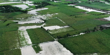
Once agriculture can control what happens to each plant, it will be possible to apply chemicals more precisely. In small farms, farmers can also control manually, but the area of sown fields does not always allow this to be done quickly. Most of the assessments made in such cases are done on the ground with the help of an expert group visiting the fields. From the plane it is impossible to assess the full scale of the incident. Therefore, to speed up this process, it is necessary to use aerial photography, including flying robots – unmanned aerial vehicles. Farmers will only use pesticides and fungicides where they are really needed and in smaller amounts; in this way, contamination of food and the environment with chemicals will be prevented, and money will also be saved. Such defects during sowing, such as bald spots, crop death after drought or flooding, and other factors, require operational control, which can only be provided by unmanned aerial photography.
The use of UAVs in agriculture makes it possible to: create electronic maps of fields; inventory of farmland; evaluate the scope of work and monitor their implementation; conduct operational monitoring of the state of crops; determine the NDVI index (vegetation index); assess the germination of crops; predict crop yields; check the quality of tillage; conduct ecological monitoring of agricultural lands.
Functions
– Hourly work efficiency – 16.2 hectares.
– High-precision flow meter – two-channel electromagnetic flow meter with an error of ±2%.
– Level Sensor – Continuous level sensor (with real-time pesticide loading detection and intelligent filling point prediction).
– The maximum spray flow is 7.2–8 l/min.
The relevance of the problem of using UAVs
Control over agricultural plantings is currently beyond doubt. But often from a plane it is impossible to assess the full scale of the situation in the fields. Therefore, to accelerate this process, it is necessary to use aerial photography. In agricultural production, small aircraft are traditionally used for this (in Russia – aircraft of the AN-2 type), which is quite expensive and often beyond the reach of small agricultural enterprises. Therefore, in many countries, unmanned aerial vehicles (UAVs) are used to control farmland, the cost of which, from an economic point of view, is many times cheaper than any manned aircraft.
Farmers around the world are actively exploring the possibilities of using unmanned aerial vehicles in agriculture. We are talking about some types of transportation of fertilizers, as well as monitoring pastures for the quantity and quality of biomass. Drones are becoming more and more relevant in agriculture. Aerial photography, or more precisely, planned aerial photography, is carried out using a drone with a camera that shoots in the visible and thermal range.
Why is the use of UAVs so important for agriculture? Because agriculture without a lot of quality data turns into a big problem. About half of the consumables for crop production (from liquids to pesticides, fungicides and herbicides) are simply useless, as they are spent in more quantities than they should be, or they are not in the right place, for example, in ditches between, and not under the plants themselves . The consequences of such a situation can be the most deplorable, up to the complete loss of the crop.
Once agriculture can control what happens to each plant, it will be possible to apply chemicals more precisely. In small farms, farmers can also control manually, but the area of sown fields does not always allow this to be done quickly. Most of the assessments made in such cases are done on the ground with the help of an expert group visiting the fields. From the plane it is impossible to assess the full scale of the incident. Therefore, to speed up this process, it is necessary to use aerial photography, including flying robots – unmanned aerial vehicles. Farmers will only use pesticides and fungicides where they are really needed and in smaller amounts; in this way, contamination of food and the environment with chemicals will be prevented, and money will also be saved. Such defects during sowing, such as bald spots, crop death after drought or flooding, and other factors, require operational control, which can only be provided by unmanned aerial photography.
The use of UAVs in agriculture makes it possible to: create electronic maps of fields; inventory of farmland; evaluate the scope of work and monitor their implementation; conduct operational monitoring of the state of crops; determine the NDVI index (vegetation index); assess the germination of crops; predict crop yields; check the quality of tillage; conduct ecological monitoring of agricultural lands.
An aerial photography UAV is launched, takes off and lands in automatic mode (on autopilot) along a loaded route. The UAV, flying along a pre-planned route, performs a digital survey of the area. The result of the survey are high-resolution images at the programmed points according to GPS coordinates. After completing the aerial photography route, the UAV lands at the same point from which it took off. For each image, a complete set of digital information is obtained, the coordinates of the central data point for transfer and use in conventional systems (for example, ArcView or MapInfo). Thus, all photos are georeferenced and can be stitched into one large field orthomosaic.
Aerial photography from UAVs can replace high-resolution satellite imagery for agriculture. Currently, precision farming is widely used in agriculture. It is based on a new view of agriculture, in which the agricultural field, heterogeneous in relief, agrochemical nutrient content, needs to be applied at each site of the most effective agricultural technologies.
UAVs for agriculture can solve many problems faster and cheaper than satellites. This means that the timely execution of work, shooting on the same day will help to take prompt action on the most pressing issues. And at the same time, changes in the situation over time will also be promptly reflected.
The purpose of agricultural surveys is to show farmers what they cannot see from the surface, and time frames are especially important in this case. When conducting regular aerial surveys of agricultural land daily or once a week and post-processing them in specialized software, it is possible to trace the dynamics of changes within the same field, and these data can be accurately correlated with land productivity.
In addition, aerial photography data can be a marketing tool. Some seed companies provide free aerial photography of the crop as part of the sale. At the same time, agricultural survey data is more than just a guide to planting tracking. Monitoring plantings using imagery can make a qualitative difference in the monitoring of agricultural activities, help prevent unnecessary costs for fertilizers and water, and some consumers are often willing to pay more for products grown using aerial photography, and thereby prefer sustainable agriculture. and rely on organic farming.
conclusions
- The use of unmanned aerial vehicles ensures the observation of plants during their growing season and the rapid identification of crops that require urgent fertilization.
- With the help of information obtained by drones, it is possible to use agricultural machines and units more rationally by compiling electronic maps of fields.
- Drones make it possible to analyze the results of sowing and quickly take measures to improve the work of machine operators, for example, to optimize the routes of equipment,
crop protection. - The drone can be used regardless of the landscape.
UAV as the basis of agriculture in the near future
Agricultural drones are an innovative trend in the development of farms. UAVs are capable of conducting various types of research that are inaccessible to an ordinary person. With a specific weight of only a few kilograms, agricultural drones are able to stay in the air for a long time and inspect areas of impressive size during this time.
Agricultural drones make it possible to create electronic maps of fields in 3D format, calculate the vegetation index) in order to effectively fertilize crops, take stock of ongoing work and protect farmland.
Let us consider in more detail examples of work that can be performed by agricultural drones.
– Analysis of the state of the soil. With the help of cameras and sensors specially installed on UAVs, farmers analyze the condition of the soil in various areas and determine which of them is most appropriate for planting seeds.
- Planting seeds. There are currently a number of startups on the market that offer to plant plants using special drones that shoot seed capsules into the soil. An example of such a startup is BioCarbon Engineering, which made a name for itself in the spring of 2015 when it announced plans to plant up to 1 billion trees a year.
– Monitoring the state of the crop. It is very important for farmers to detect pests that kill farmland in a timely manner in order to promptly take the necessary measures. It has long been known that the first signs of deterioration in the condition of plants are manifested in a change in chlorophyll.
Therefore, by installing infrared cameras on UAVs, farmers can learn in a timely manner about the beginning of crop failure. - Harvest processing. Another potential area of application for UAVs in agriculture is the uniform spraying of crops with pesticides and special fertilizers. With the help of drones, farmers will be able to carry out such work remotely.
– Yield forecast. The data collected during the monitoring can be used to build various analytical reports. In this case, the UAV will be used as a data collection platform, while the main scope of work will fall on specialized software that processes the collected information. Many experts even believe that the future of agricultural UAVs lies precisely in this development model – the devices themselves will become “commidity”, while the main value for the market will be specialists who are able to make the right decisions on the further development of farmland based on the results of the software.
Market Review
At the moment, the market for agricultural UAVs is at an early stage of development. However, experts believe that agriculture will become one of the largest market segments for drones in the future. Markets and Markets in 2016 estimated the market for agricultural UAVs at $864.4 million, predicting a steady annual growth of 30% to $4.2 billion by 2022. According to Markets and Markets experts, the market growth will be facilitated by the gradual improvement in the regulatory environment, which is now observed in various countries of the world.
Analyst agency PWC estimates that in a few decades the market for agricultural drones alone (not including aircraft-type drones) could be about $32.4 billion. This growth will be driven by an increase in the global population to feed everyone, without innovation in the agricultural industry that allows to increase productivity, is indispensable.
Among the countries where the active use of agricultural drones is now taking place, one can single out the USA, China, Japan, Brazil, the EU countries, etc. DJI, Yamaha and others. Experts note that in recent years, agricultural producers have begun to show a high interest in the use of UAVs. In particular, the American company Raven, which is a distributor of AgEagle drones, recently signed long-term cooperation contracts with leading manufacturers of agricultural equipment – Deere & Company and AGCO Corporation.
Drones are developing in the agricultural industry and in our country, even despite the not very favorable regulatory and legal regulation.
- Law on quadcopters in the Russian Federation 2022. Do I need to register a quadcopter? 150 instead of 250 grams. [Electronic resource] // Profpv.ru: site. URL: https://
profpv.ru/zakon-o-bespilotnikah-v-rf-nuzhno-li-reg/ (accessed 07/25/2022). - Drone and quadcopter – what’s the difference? [Electronic resource] // Slysky.ru:
website. URL: https://slysky.ru/blog/between-dron-and-quadrocopter.html (Accessed 07/25/2022). - Agricultural drone DJI Agras T30. [Electronic resource] // Paragraf.ru: site. URL:
https://www.paragraf.ru/product-page/agrodrone-dji-agras-t30 (date of access
07/25/2022). - Karaev V.V., Nartikoeva L.G. Drones in agriculture.
[Electronic resource] // Russiandrone.ru: site. URL: https://russiandrone.ru/
publications/bespilotniki-v-selskom-khozyaystve_/ (accessed 07/25/2022). - Sergeev K. Drones in agriculture. // resource saving
agriculture. – No. 2. – 2013. - UAV as the basis of agriculture in the near future. [Electronic resource] // Rusdrone.ru: site. URL: https://rusdrone.ru/news/BPLAkakosnovazemlede
liyablizhayshegobudushchego/ (accessed 07/25/2022). - Drones in agriculture. [Electronic resource] // Tadviser.ru: site.
URL: https://www.tadviser.ru/index.php/Article: Drones_in_agriculture
(accessed 25.07.2022). - Drones are used in the fields of the Samara region to control weeds.
[Electronic resource] // Agrarii.com: site. URL: https://agrarii.com/na-poljahsamarskoj-oblasti-ispolzujut-drony-dlja-borby-s-sornjakami/ (accessed
07/25/2022). - Agricultural quadrocopters. [Electronic resource] //
Rusgeocom.ru: site. URL: https://www.rusgeocom.ru/catalog/bespilotniki-dlyaselskogo-khoziajstva (Accessed 07/25/2022). - Drones in agriculture. [Electronic resource] // Geomir.ru:
website. URL: https://www.geomir.ru/publikatsii/bespilotniki-v-selskom-khozyaystve/
(accessed 25.07.2022).
